EARTH IS THE AIM 7 , Mu and the other worlds
Chapter 24 : Mu
The legends of Mu
Many legends did arrive to us concerning Mu , as well on many other mysteries of our ancient history
Generally , talented writers take them as a base and tell us extraordinary stories
Unfortunately , these extraordinary stories do not often relate the truth or the coherence of the real story
But they are much better sold
Unfortunately , it also makes to people’s eyes the legends being mythic
Personally , and you have been able to see it since the Volume 1 of this book , I consider the legends as true stories
So I am interested by studying how this true story could fit with the coherence of the history of the men
I am helped by our constantly evolving knowledges and the latest archaeological discoveries
And then very often , the legend becomes possible and in addition fits exactly in the geographical place and period , at the exact moment where it happened
As you will see it now , Mu is not an exception to the rule
The Voyage of the « Beagle »
Charles Darwin participates at the trip around the world of the vessel « The Beagle » from December 27th , 1831 up to October 2nd , 1836
He does geological observations and collect a huge collection of fossils
At each stopover , he sends them to Cambridge , accompanied by letters
His detailed notes will form the basis of his work
The diary he writes on board , in which he recapitulates his observations , has been published under the title of :
« The Voyage of the Beagle »
Before the departure , the Beagle captain , Robert Fitzroy gave to Darwin the first volume of Sir Charles Lyell’s Principles of Geology
Darwin thus discovered Sir Charles Lyell’s theory about the formation of terrestrial reliefs by erosion or addition of materials over very long periods of time
At their first stopover in the island of Santiago in the Cape Verde , Darwin discovers white bands high in the cliff , who reveals to be composed of coral and shells fragments
This confirms Lyell’s theory of the slow rise or descent of reliefs
He will then start his book on Geology
He discovers that the plains of Patagonia consist of pebbles and shells , in Chile , that mussel beds are located above the sea level and in the Andes , that the fossilized trees have grown on a beach made of sand and sea shells
All these observations will enable him to establish that the coral atolls are formed on volcanic cones being submerged
Darwin the geologist
It is quite extraordinary that Darwin was able to draw such a precise and accurate map of the world’s coral reefs in 1842
To achieve this level of quality we needed the satellite views of the early 21st century
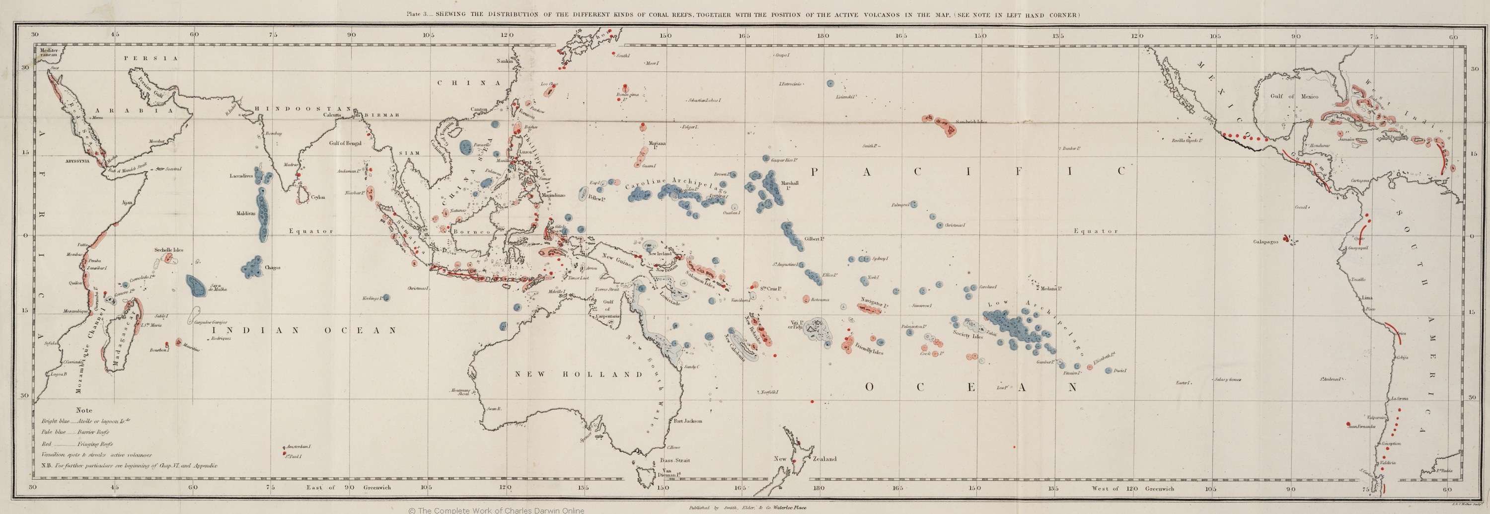
Darwin’s map of 1842 extract from :
The structure and distribution of coral reefs
Part of : Geology of the voyage of the Beagle , under the command of Capt. Fitzroy , R.N. during the years 1831 to 1836
With the kind permission of Darwin Online
http://darwin-online.org.uk/graphics/Geology_Illustrations.html
Darwin’s map shows the position of the coral reefs in the Pacific and Indian Oceans
In red dots , active volcanoes
In red the fringing reefs
In light blue barrier reefs
In dark blue , the atolls
So for his trips he had to have a reliable source :
An ancient map
Of course the Voyage of the Beagle was not a voyage of discovery , it was a confirmation trip of the datas of his old map
Of course , he did not talk about it because he would have been even more vilified by the scientific community of the moment , totally imbued with certainties
A famous scientist of the late 19th century prefaced a chemistry book of one of his colleagues with the following words :
« This treatise of chemistry summarizes very well all our knowledge , to which there is nothing to add , because we have already discovered everything »
And I can certify you that these words are the ones of this preface , as I got in my hands this chemistry treatise book
That shows quite the mentality of the scientific intelligentsia of this period
Atoll’s forming
The corals grow near the surface
The corals form a crown that almost completely surrounds the shallowed island
With the collapse of the Earth’s crust , usually of tectonic or thermal origin , the shoreline of the island sinks
That makes the corals grow as they want to stay close to the surface
The distance between the island and the coral ring increase then over time , and the island will start to disappear
The process will then be accelerated with the very effective erosion in the tropical climates
There will then be no more as a coral ring :
An atoll
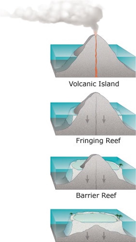
Atoll forming : http://pubs.usgs.gov/fs/2002/fs025-02/
Coral atolls develop from reefs fringing volcanic islands
As first hypothesized by Charles Darwin , and confirmed by ocean drilling done by British scientists a century ago ,
reefs fringing volcanic islands build vertically to sea level , forming steep walled barrier reefs
As a volcanic island subsides , or sinks , with time , the growing reef keeps place with the rising water level
When the island eventually submerges , the ring-shaped reef forms an atoll with a central lagoon
Graphic Design By Susan Mayfield and Sara Boore
Photo Wikipédia Public Domain : Salleman~commonswiki
Mu
Mu , or Kasskara , is not a myth
Mu did indeed exist
Mu was located in the Pacific Ocean , that’s for sure , since the Hopis in their legends leave Kasskara in rafts to join the Andes Mountain range
Thanks to the works of Charles Darwin , we can now situate Mu quite precisely
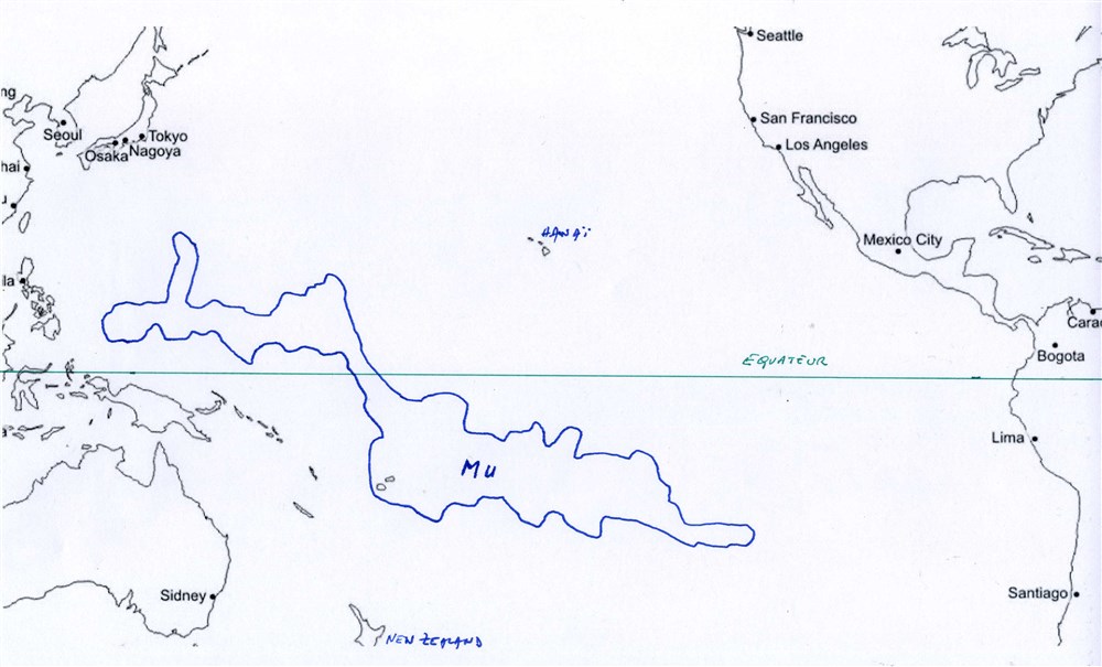
Map background : http://d-maps.com/
Douglas Moonstone drawing
According to the evidence in our possession , here is the location of Mu
Indeed , the Pacific Ocean is renowned for its depth
But it exists a whole area , where only small islands remain today and where the depth remains low :
The atoll area identified by Charles Darwin on his 1842 map confirmed by the World Resources Institute in 2011
There is no doubt therefore that this area was the continent of Mu , now sunk
And it is also confirmed by the Hopi legend :
” The name of the third world was Kasskara . Few people today know the meaning of this very old word. I learned it from Otto Péntewa who remembered it, it means “Mother Earth”. We also call it “the land of the Sun” because we like to refer to the Sun and the Earth that keep us alive.
Kasskara was a continent. Perhaps it was the same who is called today Mu. Most of the continent was at the South of the Equator, only a small part was in the North. It was a very beautiful country. Compared to today , it was almost a paradise. “
Finally , a very volcanic paradise …
But in reality , there is quite no non-volcanic area on Earth or under the sea
The end of Mu
” And then – as my grandmother used to say it – someone pressed the wrong button and both continents sank. It was not the universal flood. The whole Earth was not destroyed and not all men were killed. Atlantis sank very quickly into the ocean, but our third world, Kasskara , sank very slowly. “
” Meanwhile, people were very scared because the old continent was sinking deeper and deeper. They were afraid and yet they knew they had to be saved. One city after another was destroyed. The water did not stop rising and covered a large part of the continent. “
” When we were standing on the coast of this continent
( South America ) , we looked back and saw the islands sinking. The Kachinas gave us the third eye and we saw everything :
The disappearance of our Mother Earth and the islands. “
” A long time passed between the arrival of the first peoples
( In South America ), on flying shields , and the last ones , by boats. It is said that it took 3000 years for us to be all together. All this happened a long time ago, because the arrival of those who were on the flying shields took place
80 000 years ago. We have a very simple way of talking about the big periods of time : a Soomody means 1000 years, Soo means Star and you know how many stars there are !
4000 years are only four Soomody and there are 80 Soomody since the migration started. “
The story of Mu
Towards -204 060
« At the end of the second world , the Earth thus had only 2 continents »
« It was destroyed by water for the same reason , the Earth rocked half , the land was swallowed up and two new continents appeared , a large one , Kasskara or Mu and a small one , Talawaitichqua or Atlantis »
Early in the third world , when the Earth was stabilized , the melting ice flooded the lands and the waters returned and so the continents reappeared
Towards -100 956
The movement of the waters of the beginning of the fourth world ended up by drowning the continents of Mu and Atlantis , leaving only the summits of America and Asia to emerge
But once the water’s stabilized , Atlantis reappeared and was again inhabited
But for Mu , this new flood caused massive erosion that led to its gradual disappearance
So we can say that towards -80 000 , Mu began to sink , and then disappear totally towards -40 000 , with all the technological infrastructures of the Neanderthals
As the Neanderthals have lost their mother land , those who lived in the other continents ended up by being absorbed by the Sapiens
The ” pure ” Neanderthals then definitively disappear towards -30 000 to make way for the modern Sapiens , the Sapiens of today , mixed with Neanderthals
Comments are welcome
See you soon again with a new post

You can buy my books here :


