
EARTH IS THE AIM 5 , The Indo-Europeans
Chapter 28 : The Arab kingdoms : Saba
The kingdom of Saba
If it is obvious that the kingdoms of Dilmun and Magan are composed of state-cities , which are in fact mandataries of the Thar valley , Marhashi , Sumer , Elam and Scythians kingdoms
It is also evident that the kingdom of Saba , in the West of Arabia , was founded by the Tokharians
The proof is that it is mainly in this kingdom of the Arabian Peninsula that we find the most petroglyphs and megalithic constructions that characterize them , even if the presence of Tokharians communities is also established within certain state-cities of Magan and Dilmun
The kingdom of Saba includes the Southwest and the West of the Arabian Peninsula
As early as 3000 BC , there are bronze idols in the sites of small villages that already practiced irrigated agriculture
Thanks to this irrigation , they already obtained the double harvest on one year on the terraces of the mountains
The archaeologists recognize for this kingdom , during the Bronze Age , important social groups , with complex structures , interconnected with each other and with the rest of the Atlantean world which practiced breeding , made elaborate ceramics and mastered metallurgy
We recognize the Tokharian technology , petroglyphs and megaliths in this kingdom
The Megalithic sites of Arabia
The megalithic complexes of Arabia settle up from the Western Oman , then from Yemen and Western Saudi Arabia up to the Sinai , Jordan , Syria and Lebanon
They have been dated from the early 3rd millennium BC , thanks to the painted jars imported from Mesopotamia
The tall circular tombs , the tumuli and the sets of erected stones are of similar orderly construction throughout Arabia which confirms a structured and homogeneous civilization
Their implementation is usually the following :
The high circular tombs are on the plateaux , at the edge of the cliffs
The tumuli are perched on the hills
The standing stones are at the foot of the jebels , high hills or mountains
The triliths are located in wâdîs , river plains that can be seasonally dry
The many Bronze Age megalithic sites located along the Incense Trail , prove the permanent contacts across the Arabian Peninsula
From Ramlat Dahm up to Ramlat As-Sab’Atayn
The Ramlat Dahm and As-Sab’Atayn , located at the North of the Yemen , are dotted with megalithic burials :
The jabal necropolis of Ruwaik , the Wadi Nushur , the high circular tombs on the Sanaa-Sa’Ada road , the Mawr site near Saada , the sites of the road from Sanaa up to S’Ada , Sanaa up to Marib and Mu , the Jabal Ruwaik tumuli , the tumulus of the Mukalla Plateau at Sayyun , and so on …
There are many tall circular tombs , called in Arabic :
Dirm
But also erect stones , tumuli and cysts or small dolmens , sites of erected stones , triliths , tombs walls , kind of large walls with two facing , in the middle of which is a funerary chamber shaped caisson , rectangular tombs with one or two stones standing at the East of the tomb , square tombs , funeral chains formed by rectangular boxes and rows of erect stones long over one hundred meters
These structures are very important
The mapping of the high circular tombs revealed the strategic position of these necropolises :
Along the tracks across the desert that connect Shabwa to the Jaw
They date from the 3rd and the 2nd millennium BC
This confirms the trade links between Lebanon , Yemen and Oman
Dhamar
In the plain of Dhamar , at more than 2000 meters of altitude we find erected stones and dolmens , and a covered path of
8m long covered by 7 horizontal slabs in which in the middle one misses
A city with its water recovery system made of huge tanks , shows the technology and the wealth of the region
Tihama
In the plain of Tihama 126 sites were discovered on 30 km² They are shells and mounds of ceramic shards and erect stones
The shell clusters are composed of remains of terebralia shells palus sort , a mangrove mollusc , mainly used as bait for fishing and as a raw material for the production of lime
There are also pieces of ceramics and bronze fragments
A large number of bones of equids and caprines , proves the practice of breeding
The shells clusters are dated from the 7th millennium BC and the ceramic fragments and the bones from the 3rd millennium BC
In addition to the famous standing stones of Hamili , there are also several rows of stones of more than one kilometer , of 1 to 3 meters high , perfectly bevelled down of the Jabal
Al-Mahandar
At the North of the city of Zabid , there is still a site of erect stones
The excavation of the front part of a monolith revealed two copper blades , two heads of axes , two spears of javelins , dated from 2500 BC
Ceramic , copper , bronze , breeding , megaliths , that is the technology of the Tokharians !
Mahra and Dhofar
The Mahra in Yemen and the Dhofar in Oman , form a narrow coastal strip of about 40 km at the South of the Arabian Peninsula
Many triliths have been discovered along the wâdîs
But also tumuli on the road that connects Sayhut to Qishn
This area has also revealed cistus or small dolmens , and erect stones
The most remarkable site is the site of Al-Madhî
In the Mahra and the Dhofar are erected numerous triliths
The numerous remains of ceramic we discovered there is dated from the 3rd and the 2nd millennium BC
Wadi Was’Sha
In the Wadi Wa’Sha , the burial remains and traces of habitat discovered are dated from the late 4th millennium up to the middle of the 3rd millennium BC
Circular towers , wall tombs , cyst tumuli and dolmens were found there
The megaliths form trapezoidal structures and include alignments of triliths
One of the most important trilith sites , listed HDOR 592 , has more than fourteen alignments that span more than
300 m long
Small circular structures are associated with these alignments
The orientation of the alignments follows that of the bed of the Wadi
Wadi Rum
In the Wadi Rum or Wadi Ramm , at the South of Arabah in Jordan there are many canyons , natural arches , cliffs and caves with drawings , engraved inscriptions and archaeological remains testifying of 12 000 years of human occupation
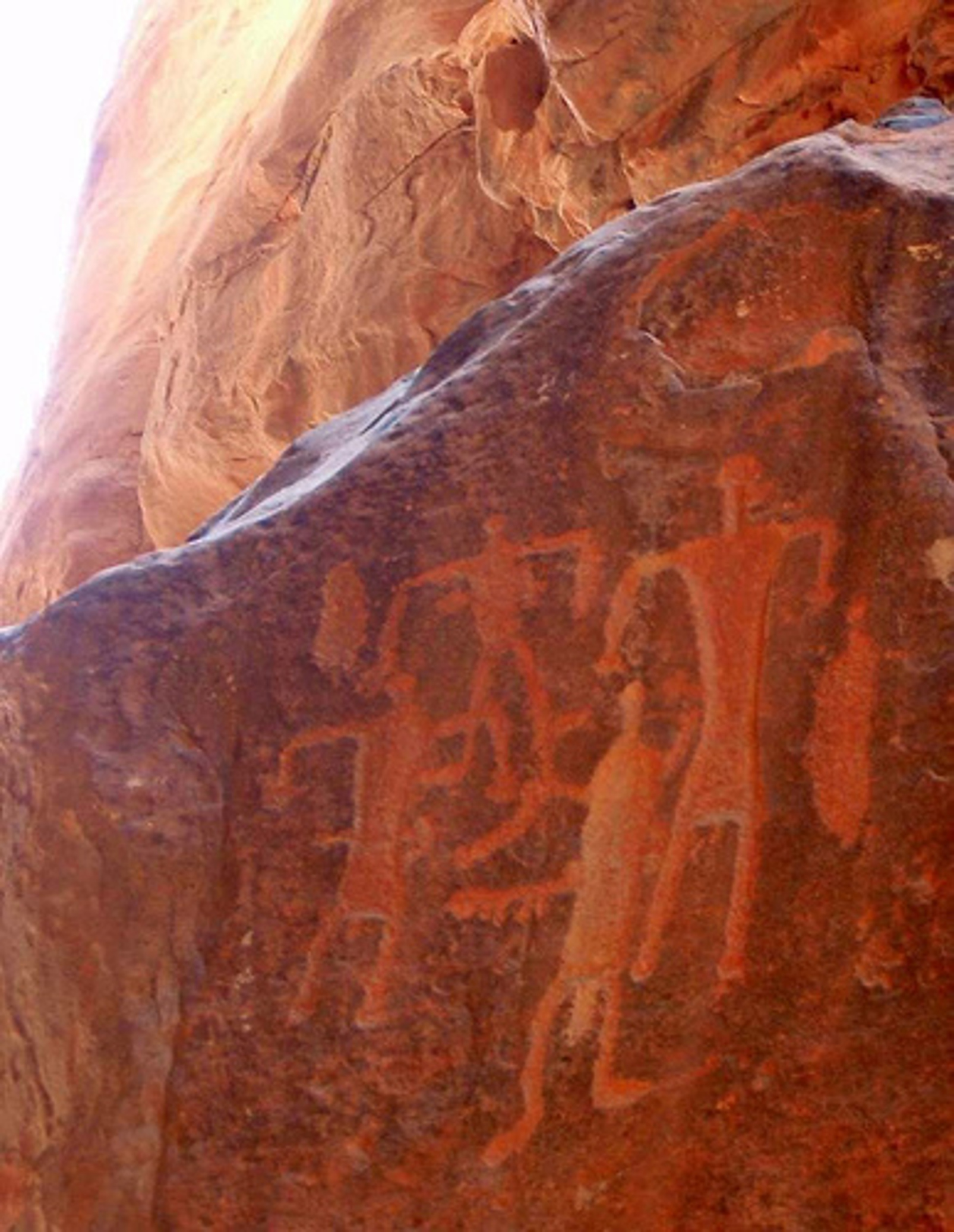
Wadi Rum Petroglyph
Photo Wikipedia CC : Heji Kim, Grumpygreen
Over 25 000 petroglyphs and more than 20 000 texts which trace the beginnings of the alphabetic writing , have been listed there
Hadramawt
The Hadramawt is mentioned in the Book of Genesis and its capital is Shabwa
Shabwa , with his 10 m tall tell , would be from earlier than the middle of the second millennium
In the Hadramawt we find traces of occupation prior to the second millennium , but its ancient history is totally unknown to us today
His story is known to us from various foreign sources , but only from the 7th century BC , long after when the Tokharians have established the kingdom of Saba
The inhabitants of Hadramawt practiced irrigated agriculture , built houses and brick palaces , made red slip ceramic
The other ancient cities of the region bear witness to the same culture and include one or more palaces
Many cities line the coast of the Indian Ocean and the Red Sea , as well as along the land trade routes , including Habbân , Naqab Al-Hajar , Al- Bîna , Bir Ali
Dedan
Dadan , Dedan , or Dedanim designates a people of Edom or Arabia , according to Isaiah , Jeremiah, and Ezekiel , from the 7th and the 6th century BC
According to them , this people dwelt in the Arabia Desert
The Dedantites were traders who had a considerable traffic with Tyr
They came there by caravans to bring ivory , ebony and magnificent covers of horses , produced without any doubt by foreign countries which they received from farest nations by the different harbours of Arabia
Isaiah threatened invading Arabia , and asserted that the trade which made the wealth of these populations , and among others those of Dedan , will be destroyed
Barbié du Bocage , founder in 1821 of the Geographical Society , place Dedan in the Persian Gulf , on one of the Bahrain Islands
For him , Idumée is located in Africa , in a country whose Eastern limit does not exceed the 34th degree of longitude
We thus find the trace of ancient texts which affirmed that the kingdom of Saba was located on the East coast of Africa and on the West coast of Arabia
This territorial establishment corresponds well to the Tokharians
The road of the kings
The Kings Road is a 335-kilometer-long passage that connects Ammam to Aqaba in Jordan
It is bordered on both sides by a rich chain of archaeological sites with Stone Age prehistoric villages , biblical cities of the Ammon , Moab and Edom kingdoms , crusader castles , some of the most beautiful early Christian Byzantine mosaics from the Middle East , a Roman Herodian fortress , several Nabataean temples , two major Roman fortresses , ancient Islamic cities and the Nabatean capital carved out of the rock :
Petra
Mentioned in the Bible , the road of the kings was the one Moses wanted to follow to take his people up to the North through the Edom region
In Genesis 14 , an alliance of ” four kings of the North ” led his troops on this road to fight against the five kings of the cities of the plain , including the cities of Sodom and Gomorrah
These mentions prove the antiquity of this road of the kings , a small part of the road of the incense

Nabataeans’ commercial roads
Photo Wikipedia CC : Like tears in rain
The incense road
The incense road linked Egypt to Arabia and India
It was created at the beginning of the 3rd millennium BC
The Aryans of the Thar Valley sent incense to the ports of Arabia and Egypt :
Cane , Aden and Muza in the south and Bérénice , Philotera , Myos Hormos , Leuce Kome and Aila at the North
The incense which arrived in the harbours of Arabia was then sent by caravan through the desert until Petra , where it transited for Gaza and Damascus
From the ports of Egypt , it was transported up to Alexandria via Coptos
The incense route has also been used for international trade in myrrh , Indian spices , ebony , silk , rare woods , feathers , skins , and so on …
Several cities were founded in the oases along the road , including Iram and Saba
In the Negev Desert , have been found the cities of Avdat Haluza , Mamshit and Shivta
The cities of this road have been equipped with extremely sophisticated irrigation systems
The history of the Kingdom of Saba
More than 5000 years ago , the archaeological excavations in the Arabian Peninsula proved the existence of links with the civilizations of the Middle East , Mesopotamia and India
So it was well the Tokharians who founded the kingdom of Saba and its capital , Marib
The reconstruction of the route of the old roads showed that the cities were founded at the edge of one of the many tracks that the caravans took
The most important of these ancient roads left from Aden , crossed the Asir and Hedjaz in the direction of the North , then the water and supply point of Mecca , to continue towards the North
There are along these ancient roads , in Yemen , Saudi Arabia , Jordan , Sinai , Lebanon and Syria , more than
10 000 funeral complexes of common architecture
This funerary architecture is not a particularity :
It is recognized throughout the peninsula and into the Middle East as Tokharian one
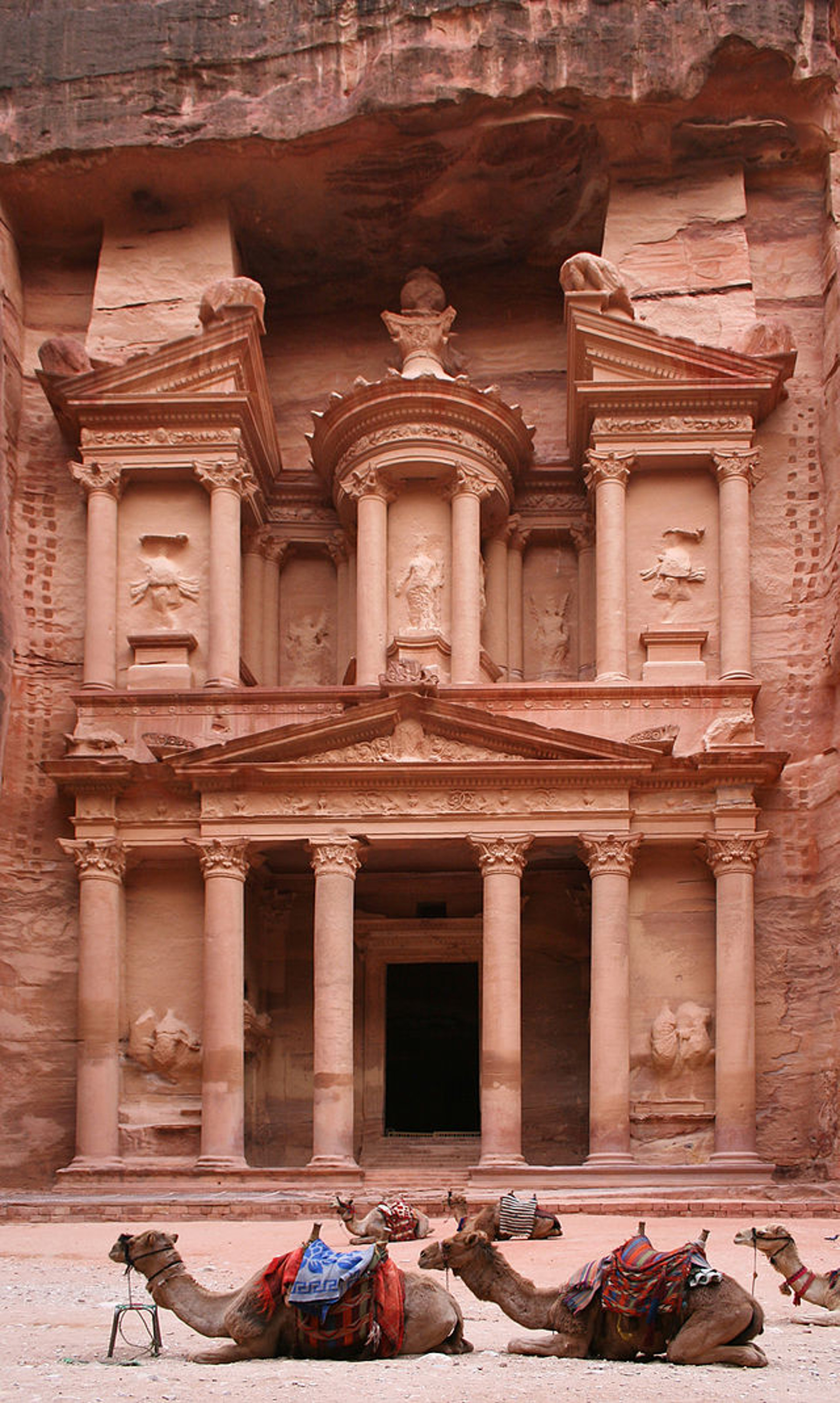
Khazneh , Petra, Jordan.
Photo Wikipedia CC : Graham Racher , Mr Pany Goff
The proven presence of agriculture , irrigation , livestock farming , metallurgical , ceramics , petroglyphs and megaliths at this period of the Neolithic , corresponds to a Tokharian kingdom
After the Yi Wars and the collapse of the Aryans and the Tokharians , the Nabataeans inherited the secrets of the trade routes and took control of them
The city of Petra became then their capital instead of Marib
Comments are welcome
See you soon again with a new post
You can buy my books here :


